


Assessment and monitoring of rangeland health at the national level
ASSESSMENT AND MONITORING OF RANGELAND HEALTH AT THE NATIONAL LEVEL
The National Agency for Meteorology and Environmental Monitoring (NAMEM) is the institution responsible for nationwide rangeland monitoring covering 1516 monitoring sites representing all baghs in Mongolia. NAMEM has achieved significant progress to i) institute measurement of internationally-accepted core indicators that are standardized nationally; ii) develop a reference database of different rangeland types that provides a basis for interpreting monitoring data and determining what is “healthy” or “degraded”(ecological site descriptions); and iii) build capacity to produce a timely outlook on rangeland health based on monitoring data. Comparisons of existing rangeland monitoring methodologies used by different Mongolian institutions (Research institutes; Universities; Ministry of Environment, Green Development and Tourism; Ministry of Food, Agriculture and Light Industry; National Agency for Meteorology and Environmental Monitoring and the Administration of Land Management, Geodesy and Cartography) led to an agreement on a unified set of core indicators that will reduce controversy in assessments of rangeland health into the future. Core indicators include foliar canopy cover, species composition, and basal gaps of perennial plants, plant height, and biomass. Measurement methods include line-point intercept, gap intercept, air dry biomass at 1 cm clipping height, and photo points. A methodology for rapid characterization of soils to identify ecological sites and a concept for developing simplified ecological site descriptions that match existing herder concepts (see below) were also agreed upon. The newly standardized methodology is repeatable, precise, and simple enough for easy use. The method can not only be used to report rangeland health at a point in time (assessment), but also provide precise estimates of rangeland change over the long-term (monitoring). As of 2011, the new methodology and indicators were approved by the Government as a nationwide monitoring methodology. Monitoring sites at the NAMEM are able to fully represent the ecological and administrative boundaries of Mongolia (Fig.1.1.1).
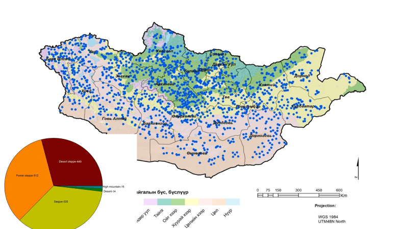
Figure 1.1.1 Dot map for the rangeland monitoring sites
Meteorology technicians in 320 soums collect the primary data yearly at 1516 sites using the new standardized methodology since 2011. Aimag engineers ensure quality control and enter the monitoring data into the National Rangeland Monitoring Database. The national database is modified and adapted to Mongolia from the Database for Inventory, Monitoring and Assessment developed by the U.S. Department of Agriculture (USDA), Jornada Experimental Range. The database can accommodate all core indicators and new indicators as needed. Customized reports for interpretation of assessment and monitoring data can be produced.